Galerie d'images
Toutes les images de la base — taxons, formations et intervalles géologiques.
⚠ La fonctionnalité de récupération des images est en cours de test, des images non pertinentes peuvent apparaître.
4,826 image(s)


Sandstones of the Milk River Formation flank the Milk river at Writing-on-Stone Provincial Park, Alberta.

Hoodoos

Bryce Canyon geologic map, showing a variety of rock formations in the national park including the Claron Formation, which forms the park’s famous red hoodoos.

Locality map: Grand Staircase-Escalante National Monument, southern Utah. Map showing the Nipple Butte area (indicated by yellow star) of Grand Staircase-Escalante National Monument (GSENM). GSENM is bounded by the red rectangle and silhouetted in dark gray on the inset of Utah and surrounding states (modified from [1]). The original map has been modified to show the Nipple Butte area instead of the Machairoceratops fossil locality as in the original source. New location based on map in A New Macrovertebrate Assemblage from the Late Cretaceous (Campanian) of Southern Utah, page 601.

Locality map: Grand Staircase-Escalante National Monument, southern Utah. Map showing locality (indicated by star) of Nasutoceratops titusi holotype UMNH VP 16800, recovered from the Kaiparowits Formation of Grand Staircase-Escalante National Monument (GSENM). GSENM is bounded by the red rectangle and silhouetted in dark gray on the inset of Utah and surrounding states (modified from [1]). The original map has been modified to show Nasutoceratops instead of Machairoceratops as in the original source. New location based on map in Ceratopsid Dinosaurs from the Grand Staircase of Southern Utah, page 489.

Locality map: Grand Staircase-Escalante National Monument, southern Utah. Map showing locality (indicated by star) of Kosmoceratops richardsoni holotype UMNH VP 17000 and assigned subadult UMNH VP 16878, recovered from the Kaiparowits Formation of Grand Staircase-Escalante National Monument (GSENM). GSENM is bounded by the red rectangle and silhouetted in dark gray on the inset of Utah and surrounding states (modified from [1]). The original map has been modified to show Kosmoceratops instead of Machairoceratops as in the original source. New location based on map in Ceratopsid Dinosaurs from the Grand Staircase of Southern Utah, page 489.

Kaiparowits Formation (Campanian; Upper Cretaceous) at The Blues, near Powell Point (peak to the left) composed of the Claron Formation.

Natural-colour satellite image of part of the Kaiparowits Basin (a central portion of Grand Staircase-Escalante). The branch-like shapes are networks of canyons carved by rivers that dried up millions of years ago. The ridge running roughly north-south through the scene is the Cockscomb, which is surrounded by distinct rock formations deposited at different times in the geologic past. West of the Cockscomb is the Navajo Sandstone, dating from the Triassic. East of the Cockscomb are two formations from the Cretaceous: the light-toned Wahweap and darker Kaiparowits.

View of Shestakovsky Yar (paleontological site Shestakovo-1) from the Kiya River.

Остеодерма анкилозавра (Ankylosauria indet.) в музее при местонахождении Шестаково-3 (илекская свита).

Палеонтологическое местонахождение Шестаково-3 (илекская свита, нижний мел), июль 2021 года.

A visitor center for guests of the Shestakovo-3 paleontological site in the Chebulinsky district of the Kemerovo Oblast. Large green letters read "Shestakovo-3".


Precious opal from Australia. (public display, Denver Museum of Nature & Science, Denver, Colorado, USA) A mineral is a naturally-occurring, solid, inorganic, crystalline substance having a fairly definite chemical composition and having fairly definite physical properties. At its simplest, a mineral is a naturally-occurring solid chemical. Currently, there are over 4900 named and described minerals - about 200 of them are common and about 20 of them are very common. Mineral classification is based on anion chemistry. Major categories of minerals are: elements, sulfides, oxides, halides, carbonates, sulfates, phosphates, and silicates. The silicates are the most abundant and chemically complex group of minerals. All silicates have silica as the basis for their chemistry. "Silica" refers to SiO2 chemistry. The fundamental molecular unit of silica is one small silicon atom surrounded by four large oxygen atoms in the shape of a triangular pyramid - this is the silica tetrahedron - SiO4. Each oxygen atom is shared by two silicon atoms, so only half of the four oxygens "belong" to each silicon. The resulting formula for silica is thus SiO2, not SiO4. Opal is hydrous silica (SiO2·nH2O). Technically, opal is not a mineral because it lacks a crystalline structure. Opal is supposed to be called a mineraloid. Opal is made up of extremely tiny spheres (colloids - <a href="https://www.uwgb.edu/dutchs/acstalks/acscolor/OPALSPHR.jpg" rel="nofollow">www.uwgb.edu/dutchs/acstalks/acscolor/OPALSPHR.jpg</a>) that can be seen with a scanning electron microscope (SEM). Gem-quality opal, or precious opal, has a wonderful rainbow play of colors (opalescence). This play of color is the result of light being diffracted by planes of voids between large areas of regularly packed, same-sized opal colloids. Different opalescent colors are produced by colloids of differing sizes. If individual colloids are larger than 140 x 10-6 mm in size, purple & blue & green colors are produced. Once colloids get as large as about 240 x 10-6 mm, red color is seen (Carr et al., 1979). Not all opals have the famous play of colors, however. Common opal has a wax-like luster & is often milky whitish with no visible color play at all. Opal is moderately hard (H = 5 to 6), has a white streak, and has conchoidal fracture. Several groups of organisms make skeletons of opaline silica, for example hexactinellid sponges, diatoms, radiolarians, silicoflagellates, and ebridians. Some organisms incorporate opal into their tissues, for example horsetails/scouring rushes and sawgrass. Sometimes, fossils are preserved in opal or precious opal. The precious opal shown above is surrounded by silicified claystone. The rock is from the Griman Creek Formation, a Cretaceous-aged succession of nonmarine, fine-grained and coarse-grained siliciclastic sedimentary rocks. Stratigraphy: Griman Creek Formation, Albian Stage, upper Lower Cretaceous Locality: Coocoran Opal Field, west-southwest of Coocoran Lake, northern New South Wales, eastern Australia Photo gallery of opal: <a href="http://www.mindat.org/gallery.php?min=3004" rel="nofollow">www.mindat.org/gallery.php?min=3004</a> References cited: Carr et al. (1979) - Andamooka opal fields: the geology of the precious stones field and the results of the subsidised mining program. Geological Survey of South Australia Department of Mines and Energy Report of Investigations 51. 68 pp.

Precious opal from Australia. (public display, Denver Museum of Nature & Science, Denver, Colorado, USA) A mineral is a naturally-occurring, solid, inorganic, crystalline substance having a fairly definite chemical composition and having fairly definite physical properties. At its simplest, a mineral is a naturally-occurring solid chemical. Currently, there are over 4900 named and described minerals - about 200 of them are common and about 20 of them are very common. Mineral classification is based on anion chemistry. Major categories of minerals are: elements, sulfides, oxides, halides, carbonates, sulfates, phosphates, and silicates. The silicates are the most abundant and chemically complex group of minerals. All silicates have silica as the basis for their chemistry. "Silica" refers to SiO2 chemistry. The fundamental molecular unit of silica is one small silicon atom surrounded by four large oxygen atoms in the shape of a triangular pyramid - this is the silica tetrahedron - SiO4. Each oxygen atom is shared by two silicon atoms, so only half of the four oxygens "belong" to each silicon. The resulting formula for silica is thus SiO2, not SiO4. Opal is hydrous silica (SiO2·nH2O). Technically, opal is not a mineral because it lacks a crystalline structure. Opal is supposed to be called a mineraloid. Opal is made up of extremely tiny spheres (colloids - <a href="https://www.uwgb.edu/dutchs/acstalks/acscolor/OPALSPHR.jpg" rel="nofollow">www.uwgb.edu/dutchs/acstalks/acscolor/OPALSPHR.jpg</a>) that can be seen with a scanning electron microscope (SEM). Gem-quality opal, or precious opal, has a wonderful rainbow play of colors (opalescence). This play of color is the result of light being diffracted by planes of voids between large areas of regularly packed, same-sized opal colloids. Different opalescent colors are produced by colloids of differing sizes. If individual colloids are larger than 140 x 10-6 mm in size, purple & blue & green colors are produced. Once colloids get as large as about 240 x 10-6 mm, red color is seen (Carr et al., 1979). Not all opals have the famous play of colors, however. Common opal has a wax-like luster & is often milky whitish with no visible color play at all. Opal is moderately hard (H = 5 to 6), has a white streak, and has conchoidal fracture. Several groups of organisms make skeletons of opaline silica, for example hexactinellid sponges, diatoms, radiolarians, silicoflagellates, and ebridians. Some organisms incorporate opal into their tissues, for example horsetails/scouring rushes and sawgrass. Sometimes, fossils are preserved in opal or precious opal. The precious opal shown above is surrounded by silicified claystone. The rock is from the Griman Creek Formation, a Cretaceous-aged succession of nonmarine, fine-grained and coarse-grained siliciclastic sedimentary rocks. Stratigraphy: Griman Creek Formation, Albian Stage, upper Lower Cretaceous Locality: Coocoran Opal Field, west-southwest of Coocoran Lake, northern New South Wales, eastern Australia Photo gallery of opal: <a href="http://www.mindat.org/gallery.php?min=3004" rel="nofollow">www.mindat.org/gallery.php?min=3004</a> References cited: Carr et al. (1979) - Andamooka opal fields: the geology of the precious stones field and the results of the subsidised mining program. Geological Survey of South Australia Department of Mines and Energy Report of Investigations 51. 68 pp.

(A) Present day map of Australia with the town of Lightning Ridge indicated by the star. (B) Regional map of the Lightning Ridge region showing localities (where known) for specimens described in this text. Sealed (solid black lines) and unsealed roads (dashed lines) are indicated. The ephemeral Coocoran Lake is marked with a dotted blue line. (C) Correlative stratigraphy of the major Cretaceous depositional basins and geological units discussed in this study. The ornithopod icon and arrow indicate the approximate level of the Griman Creek Formation from which the current material pertains. Informal units are in quotation marks. Maps in (A) and (B) redrawn and modified from Bell et al. (2016) and Opal Fields—Lightning Ridge Region map produced by the NSW Department of Mineral Resources, respectively. Stratigraphy based on Toslini, McLoughlin & Drinnan (1999) and Cook, Bryan & Draper (2013). Ornithopod silhouette created by Caleb M. Brown and used under the Creative Commons Attribution-ShareAlike 3.0 Unported license.
(A) Present day map of Australia with the town of Lightning Ridge indicated by the star. (B) Regional map of the Lightning Ridge region showing localities (where known) for specimens described in this text. Sealed (solid black lines) and unsealed roads (dashed lines) are indicated. The ephemeral Coocoran Lake is marked with a dotted blue line. (C) Correlative stratigraphy of the major Cretaceous depositional basins and geological units discussed in this study. The ornithopod icon and arrow indicate the approximate level of the Griman Creek Formation from which the current material pertains. Informal units are in quotation marks. Maps in (A) and (B) redrawn and modified from Bell et al. (2016) and Opal Fields—Lightning Ridge Region map produced by the NSW Department of Mineral Resources, respectively. Stratigraphy based on Toslini, McLoughlin & Drinnan (1999) and Cook, Bryan & Draper (2013). Ornithopod silhouette created by Caleb M. Brown and used under the Creative Commons Attribution-ShareAlike 3.0 Unported license.

(A) Map of Queensland showing the extent of Cretaceous outcrop. (B) Map of the location of Dig Site Three (type locality of Haliskia), and numerous other sites in the area from which pterosaur fossils have been collected.

View north across Frenchman River of Upper Cretaceous and Paleocene age strata of the Bearpaw, Whitemud, Battle, Frenchman, and Ravenscrag Formations in the Cypress Hills of southern Saskatchewan. Foreground strata on other side of (tree lined) creek represent a slumped section. Note the bright white zone is the Whitemud Formation. View includes type area of Frenchman and Ravenscrag Formations.

View northeast across Frenchman River of Upper Cretaceous and Paleocene age strata of the Bearpaw, Whitemud, Battle, Frenchman, and Ravenscrag Formations in the Cypress Hills of southern Saskatchewan. Foreground strata on other side of (tree lined) creek represent a slumped section. Note the bright white zone is the Whitemud Formation. View includes type area of Frenchman and Ravenscrag Formations.

Detail of the stratigraphic section of the El Castellar dinosaur footprints site, Teruel, Spain.

Eubrontes dinosaur track from the Jurassic of Connecticut, USA. Trace fossils are any indirect evidence of ancient life. They refer to features in rocks that do not represent parts of the body of a once-living organism. Traces include footprints, tracks, trails, burrows, borings, and bitemarks. Body fossils provide information about the morphology of ancient organisms, while trace fossils provide information about the behavior of ancient life forms. Interpreting trace fossils and determination of the identity of a trace maker can be straightforward (for example, a dinosaur footprint represents walking behavior) or not. Sediments that have trace fossils are said to be bioturbated. Burrowed textures in sedimentary rocks are referred to as bioturbation. Trace fossils have scientific names assigned to them, in the same style & manner as living organisms or body fossils. This track was made by a theropod, a group of small to large, carnivorous, bipedal dinosaurs. The specimen comes from a Triassic to Jurassic terrestrial sedimentary succession that filled up a half graben, many of which occur along America's eastern seaboard. Such half-graben basins formed during the Triassic as the Pangaea supercontinent tried to rift apart, but failed. Pangaea successfully broke apart during the Jurassic. Stratigraphy: East Berlin Formation, Newark Supergroup, Lower Jurassic Locality: unrecorded / undisclosed site at or near the town of Rocky Hill, central Connecticut, USA Info. at: mrdata.usgs.gov/geology/state/sgmc-unit.php?unit=CTJeb%3B0 and en.wikipedia.org/wiki/Eubrontes

The type specimen of the ichnogenus Cheliceratichnus, from the Early Jurassic East Berlin Formation of Holyoke, Massachusetts.

Bifurculapes laqueatus trackway (positive hyporelief, i.e. casts on the bottom surface of the bed) from the Early Jurassic East Berlin Formation (Hartford Basin) of Holyoke, Massachusetts (not the same specimen as this one). See coin (1 U.S. cent, 19.05 mm in diameter) for scale.

Bifurculapes laqueatus trackway (positive hyporelief, i.e. casts on the bottom surface of the bed) from the Early Jurassic East Berlin Formation (Hartford Basin) of Holyoke, Massachusetts (not the same specimen as this one). See coin (1 U.S. cent, 19.05 mm in diameter) for scale.

Geologists examining an ancient en:stream bed deposit exposed below the lava flows on the western slopes of North Table Mountain.

Type section of the Cedar Mountain Formation, western side of Cedar Mountain, Emery County, Utah.

Type section of the Buckhorn Conglomerate, Buckhorn Reservoir, western side of Cedar Mountain, Emery County, Utah.

Morrison Formation (lower half), Jurassic-Cretacous boundary (K1 Unconformity) at red and orange paleosol, Cedar Mountain Formation (drab gray), and capping Naturita Formation. West of Dinosaur National Monument.

Brushy Basin Member of the Morrison Formation (multi-colored) unconformably overlain by the Yellow Cat Member of the Cedar Mountain Formation (drab color), Jessie's Twist, Emery County, Utah

Fossil eggs of the oospecies Macroelongatoolithus carlylei (believed to be the eggs of giant oviraptorosaurs) from the Cedar Mountain Formation of North America. At the SECU Dinolab of the North Carolina Museum of Natural Sciences

View east towards the Quarry Visitor Center at Dinosaur National Monument. The boundary between the Morrison Formation (Brushy Basin Member) and the Cedar Mountain Formation is just above the highest red bed.

Typical exposure of the Cedar Mountain Formation overlying the Morrison Formation, south of Green River Utah

This image shows the Cedar Mountain Formation near its type section at Buckhorn Reservoir, Utah. The formation is capped by a very thin bed of Dakota Formation. The Cedar Mountain Formation is a Cretaceous fluvial formation, about 98 million years old, that was deposited in the foreland basin of the Sevier Mountains just before it was flooded by the ocean to form the Western Interior Seaway.

World map showing Late Cretaceous metatherian locales. Europe 1. Font-de-Benon quarry, Archingeay-Les Nouillers (Cenomanian, Late Cretaceous), Charente-Maritime, southwestern France (Vullo et al. 2009) 2. Valkenburg Member, Maastricht Formation (late Maastrichtian, Late Cretaceous), southern Limburg, The Netherlands (Martin et al. 2005) Asia 3. Yixian Formation, China (Barremian, Early Cretaceous) 4. Bissekty Formation, Kyzylkum Desert, Uzbekistan (Turonian, Late Cretaceous) 5. Darbasa Formation, southern Kazakhstan (Campanian, Late Cretaceous) 6. Grey Mesa locality (Averianov 1997) 7. Barun Goyot Formation, Umuni Gobi, Mongolia (Campanian, Late Cretaceous) 8. Nemegt Formation, Omnogov, Mongolia (Maastrichtian, Late Cretaceous) 9. Djadokhta Formation, Mongolia (Campanian, Late Cretaceous) North America Alaska 9. Prince Creek Formation, Alaska (early Maastrichtian, Late Cretaceous) Alberta and Saskatchewan, Canada 10. Milk River Formation, southern Alberta, Canada (late Santonian, Late Cretaceous) 11. Oldman Formation, southern Alberta, Canada (Campanian, Late Cretaceous) 12. Dinosaur Park Formation, southern Alberta, Canada (late Campanian, Late Cretaceous) 13. Horseshoe Canyon Formation, southern Alberta, Canada (early Maastrichtian, Late Cretaceous) 14. St. Mary River Formation, Alberta and northwestern Montana (early Maastrichtian, Late Cretaceous) 15. Scollard Formation, Alberta (late Maastrichtian, Late Cretaceous) 16. Frenchman Formation, Saskatchewan (late Maastrichtian, Late Cretaceous) Montana and North Dakota 17. Judith River Formation (late Campanian, Late Cretaceous) 18. Two Medicine Formation (late Campanian, Late Cretaceous) 19. Hell Creek Formation, Montana and North Dakota (late Maastrichtian, Late Cretaceous) South Dakota 20. Fox Hills Formation, South Dakota (late Maastrichtian, Late Cretaceous) 21. Hell Creek Formation, South Dakota (late Maastrichtian, Late Cretaceous) Wyoming 22. “Mesa Verde Formation” (late Campanian, Late Cretaceous) 23. Lance Formation, Wyoming (late Maastrichtian, Late Cretaceous) 24. Ferris Formation, Wyoming (late Maastrichtian, Late Cretaceous) Utah 25. Cedar Mountain Formation (Albian-Cenomanian) 26. Dakota Formation fauna (late Cenomanian, Late Cretaceous) 27. Smoky Hollow Member, Straight Cliffs Formation (Turonian, Late Cretaceous) 28. John Henry Member, Straight Cliffs Formation (Coniacian-Santonian, Late Cretaceous) 29. Wahweap Formation (early-middle Campanian, Late Cretaceous) 30. Kaiparowits Formation (late Campanian, Late Cretaceous) 31. Iron Springs Formation fauna, southern Utah (Turonian – Santonian, Late Cretaceous) 32. North Horn Formation, Utah (late Maastrichtian, Late Cretaceous) Colorado 33. Williams Fork Formation, Colorado (late Campanian-early Maastrichtian) 34. Laramie Formation, northeastern Colorado (late Maastrichtian, Late Cretaceous) Baja California Del Norte, Mexico 35. El Gallo Formation (late Campanian, Late Cretaceous) (Clemens 1980; Lillegraven 1972; Lillegraven 1976) New Mexico 36. Fruitland and lower Kirtland Formation, San Juan Basin (late Campanian, Late Cretaceous) 37. Naashoibito Member, Kirtland Formation, New Mexico (late Maastrichtian, Late Cretaceous) Oklahoma 38. Antlers Formation, Texas and Oklahoma (Aptian-Albian, Early Cretaceous) Texas 39. Aguja Formation, West Texas (late Campanian, Late Cretaceous) New Jersey 40. Marshalltown Formation, New Jersey (Campanian, Late Cretaceous) Szalay 1994)
World map showing Late Cretaceous metatherian locales. Europe 1. Font-de-Benon quarry, Archingeay-Les Nouillers (Cenomanian, Late Cretaceous), Charente-Maritime, southwestern France (Vullo et al. 2009) 2. Valkenburg Member, Maastricht Formation (late Maastrichtian, Late Cretaceous), southern Limburg, The Netherlands (Martin et al. 2005) Asia 3. Yixian Formation, China (Barremian, Early Cretaceous) 4. Bissekty Formation, Kyzylkum Desert, Uzbekistan (Turonian, Late Cretaceous) 5. Darbasa Formation, southern Kazakhstan (Campanian, Late Cretaceous) 6. Grey Mesa locality (Averianov 1997) 7. Barun Goyot Formation, Umuni Gobi, Mongolia (Campanian, Late Cretaceous) 8. Nemegt Formation, Omnogov, Mongolia (Maastrichtian, Late Cretaceous) 9. Djadokhta Formation, Mongolia (Campanian, Late Cretaceous) North America Alaska 9. Prince Creek Formation, Alaska (early Maastrichtian, Late Cretaceous) Alberta and Saskatchewan, Canada 10. Milk River Formation, southern Alberta, Canada (late Santonian, Late Cretaceous) 11. Oldman Formation, southern Alberta, Canada (Campanian, Late Cretaceous) 12. Dinosaur Park Formation, southern Alberta, Canada (late Campanian, Late Cretaceous) 13. Horseshoe Canyon Formation, southern Alberta, Canada (early Maastrichtian, Late Cretaceous) 14. St. Mary River Formation, Alberta and northwestern Montana (early Maastrichtian, Late Cretaceous) 15. Scollard Formation, Alberta (late Maastrichtian, Late Cretaceous) 16. Frenchman Formation, Saskatchewan (late Maastrichtian, Late Cretaceous) Montana and North Dakota 17. Judith River Formation (late Campanian, Late Cretaceous) 18. Two Medicine Formation (late Campanian, Late Cretaceous) 19. Hell Creek Formation, Montana and North Dakota (late Maastrichtian, Late Cretaceous) South Dakota 20. Fox Hills Formation, South Dakota (late Maastrichtian, Late Cretaceous) 21. Hell Creek Formation, South Dakota (late Maastrichtian, Late Cretaceous) Wyoming 22. “Mesa Verde Formation” (late Campanian, Late Cretaceous) 23. Lance Formation, Wyoming (late Maastrichtian, Late Cretaceous) 24. Ferris Formation, Wyoming (late Maastrichtian, Late Cretaceous) Utah 25. Cedar Mountain Formation (Albian-Cenomanian) 26. Dakota Formation fauna (late Cenomanian, Late Cretaceous) 27. Smoky Hollow Member, Straight Cliffs Formation (Turonian, Late Cretaceous) 28. John Henry Member, Straight Cliffs Formation (Coniacian-Santonian, Late Cretaceous) 29. Wahweap Formation (early-middle Campanian, Late Cretaceous) 30. Kaiparowits Formation (late Campanian, Late Cretaceous) 31. Iron Springs Formation fauna, southern Utah (Turonian – Santonian, Late Cretaceous) 32. North Horn Formation, Utah (late Maastrichtian, Late Cretaceous) Colorado 33. Williams Fork Formation, Colorado (late Campanian-early Maastrichtian) 34. Laramie Formation, northeastern Colorado (late Maastrichtian, Late Cretaceous) Baja California Del Norte, Mexico 35. El Gallo Formation (late Campanian, Late Cretaceous) (Clemens 1980; Lillegraven 1972; Lillegraven 1976) New Mexico 36. Fruitland and lower Kirtland Formation, San Juan Basin (late Campanian, Late Cretaceous) 37. Naashoibito Member, Kirtland Formation, New Mexico (late Maastrichtian, Late Cretaceous) Oklahoma 38. Antlers Formation, Texas and Oklahoma (Aptian-Albian, Early Cretaceous) Texas 39. Aguja Formation, West Texas (late Campanian, Late Cretaceous) New Jersey 40. Marshalltown Formation, New Jersey (Campanian, Late Cretaceous) Szalay 1994)
World map showing Late Cretaceous metatherian locales. Europe 1. Font-de-Benon quarry, Archingeay-Les Nouillers (Cenomanian, Late Cretaceous), Charente-Maritime, southwestern France (Vullo et al. 2009) 2. Valkenburg Member, Maastricht Formation (late Maastrichtian, Late Cretaceous), southern Limburg, The Netherlands (Martin et al. 2005) Asia 3. Yixian Formation, China (Barremian, Early Cretaceous) 4. Bissekty Formation, Kyzylkum Desert, Uzbekistan (Turonian, Late Cretaceous) 5. Darbasa Formation, southern Kazakhstan (Campanian, Late Cretaceous) 6. Grey Mesa locality (Averianov 1997) 7. Barun Goyot Formation, Umuni Gobi, Mongolia (Campanian, Late Cretaceous) 8. Nemegt Formation, Omnogov, Mongolia (Maastrichtian, Late Cretaceous) 9. Djadokhta Formation, Mongolia (Campanian, Late Cretaceous) North America Alaska 9. Prince Creek Formation, Alaska (early Maastrichtian, Late Cretaceous) Alberta and Saskatchewan, Canada 10. Milk River Formation, southern Alberta, Canada (late Santonian, Late Cretaceous) 11. Oldman Formation, southern Alberta, Canada (Campanian, Late Cretaceous) 12. Dinosaur Park Formation, southern Alberta, Canada (late Campanian, Late Cretaceous) 13. Horseshoe Canyon Formation, southern Alberta, Canada (early Maastrichtian, Late Cretaceous) 14. St. Mary River Formation, Alberta and northwestern Montana (early Maastrichtian, Late Cretaceous) 15. Scollard Formation, Alberta (late Maastrichtian, Late Cretaceous) 16. Frenchman Formation, Saskatchewan (late Maastrichtian, Late Cretaceous) Montana and North Dakota 17. Judith River Formation (late Campanian, Late Cretaceous) 18. Two Medicine Formation (late Campanian, Late Cretaceous) 19. Hell Creek Formation, Montana and North Dakota (late Maastrichtian, Late Cretaceous) South Dakota 20. Fox Hills Formation, South Dakota (late Maastrichtian, Late Cretaceous) 21. Hell Creek Formation, South Dakota (late Maastrichtian, Late Cretaceous) Wyoming 22. “Mesa Verde Formation” (late Campanian, Late Cretaceous) 23. Lance Formation, Wyoming (late Maastrichtian, Late Cretaceous) 24. Ferris Formation, Wyoming (late Maastrichtian, Late Cretaceous) Utah 25. Cedar Mountain Formation (Albian-Cenomanian) 26. Dakota Formation fauna (late Cenomanian, Late Cretaceous) 27. Smoky Hollow Member, Straight Cliffs Formation (Turonian, Late Cretaceous) 28. John Henry Member, Straight Cliffs Formation (Coniacian-Santonian, Late Cretaceous) 29. Wahweap Formation (early-middle Campanian, Late Cretaceous) 30. Kaiparowits Formation (late Campanian, Late Cretaceous) 31. Iron Springs Formation fauna, southern Utah (Turonian – Santonian, Late Cretaceous) 32. North Horn Formation, Utah (late Maastrichtian, Late Cretaceous) Colorado 33. Williams Fork Formation, Colorado (late Campanian-early Maastrichtian) 34. Laramie Formation, northeastern Colorado (late Maastrichtian, Late Cretaceous) Baja California Del Norte, Mexico 35. El Gallo Formation (late Campanian, Late Cretaceous) (Clemens 1980; Lillegraven 1972; Lillegraven 1976) New Mexico 36. Fruitland and lower Kirtland Formation, San Juan Basin (late Campanian, Late Cretaceous) 37. Naashoibito Member, Kirtland Formation, New Mexico (late Maastrichtian, Late Cretaceous) Oklahoma 38. Antlers Formation, Texas and Oklahoma (Aptian-Albian, Early Cretaceous) Texas 39. Aguja Formation, West Texas (late Campanian, Late Cretaceous) New Jersey 40. Marshalltown Formation, New Jersey (Campanian, Late Cretaceous) Szalay 1994)
World map showing Late Cretaceous metatherian locales. Europe 1. Font-de-Benon quarry, Archingeay-Les Nouillers (Cenomanian, Late Cretaceous), Charente-Maritime, southwestern France (Vullo et al. 2009) 2. Valkenburg Member, Maastricht Formation (late Maastrichtian, Late Cretaceous), southern Limburg, The Netherlands (Martin et al. 2005) Asia 3. Yixian Formation, China (Barremian, Early Cretaceous) 4. Bissekty Formation, Kyzylkum Desert, Uzbekistan (Turonian, Late Cretaceous) 5. Darbasa Formation, southern Kazakhstan (Campanian, Late Cretaceous) 6. Grey Mesa locality (Averianov 1997) 7. Barun Goyot Formation, Umuni Gobi, Mongolia (Campanian, Late Cretaceous) 8. Nemegt Formation, Omnogov, Mongolia (Maastrichtian, Late Cretaceous) 9. Djadokhta Formation, Mongolia (Campanian, Late Cretaceous) North America Alaska 9. Prince Creek Formation, Alaska (early Maastrichtian, Late Cretaceous) Alberta and Saskatchewan, Canada 10. Milk River Formation, southern Alberta, Canada (late Santonian, Late Cretaceous) 11. Oldman Formation, southern Alberta, Canada (Campanian, Late Cretaceous) 12. Dinosaur Park Formation, southern Alberta, Canada (late Campanian, Late Cretaceous) 13. Horseshoe Canyon Formation, southern Alberta, Canada (early Maastrichtian, Late Cretaceous) 14. St. Mary River Formation, Alberta and northwestern Montana (early Maastrichtian, Late Cretaceous) 15. Scollard Formation, Alberta (late Maastrichtian, Late Cretaceous) 16. Frenchman Formation, Saskatchewan (late Maastrichtian, Late Cretaceous) Montana and North Dakota 17. Judith River Formation (late Campanian, Late Cretaceous) 18. Two Medicine Formation (late Campanian, Late Cretaceous) 19. Hell Creek Formation, Montana and North Dakota (late Maastrichtian, Late Cretaceous) South Dakota 20. Fox Hills Formation, South Dakota (late Maastrichtian, Late Cretaceous) 21. Hell Creek Formation, South Dakota (late Maastrichtian, Late Cretaceous) Wyoming 22. “Mesa Verde Formation” (late Campanian, Late Cretaceous) 23. Lance Formation, Wyoming (late Maastrichtian, Late Cretaceous) 24. Ferris Formation, Wyoming (late Maastrichtian, Late Cretaceous) Utah 25. Cedar Mountain Formation (Albian-Cenomanian) 26. Dakota Formation fauna (late Cenomanian, Late Cretaceous) 27. Smoky Hollow Member, Straight Cliffs Formation (Turonian, Late Cretaceous) 28. John Henry Member, Straight Cliffs Formation (Coniacian-Santonian, Late Cretaceous) 29. Wahweap Formation (early-middle Campanian, Late Cretaceous) 30. Kaiparowits Formation (late Campanian, Late Cretaceous) 31. Iron Springs Formation fauna, southern Utah (Turonian – Santonian, Late Cretaceous) 32. North Horn Formation, Utah (late Maastrichtian, Late Cretaceous) Colorado 33. Williams Fork Formation, Colorado (late Campanian-early Maastrichtian) 34. Laramie Formation, northeastern Colorado (late Maastrichtian, Late Cretaceous) Baja California Del Norte, Mexico 35. El Gallo Formation (late Campanian, Late Cretaceous) (Clemens 1980; Lillegraven 1972; Lillegraven 1976) New Mexico 36. Fruitland and lower Kirtland Formation, San Juan Basin (late Campanian, Late Cretaceous) 37. Naashoibito Member, Kirtland Formation, New Mexico (late Maastrichtian, Late Cretaceous) Oklahoma 38. Antlers Formation, Texas and Oklahoma (Aptian-Albian, Early Cretaceous) Texas 39. Aguja Formation, West Texas (late Campanian, Late Cretaceous) New Jersey 40. Marshalltown Formation, New Jersey (Campanian, Late Cretaceous) Szalay 1994)
World map showing Late Cretaceous metatherian locales. Europe 1. Font-de-Benon quarry, Archingeay-Les Nouillers (Cenomanian, Late Cretaceous), Charente-Maritime, southwestern France (Vullo et al. 2009) 2. Valkenburg Member, Maastricht Formation (late Maastrichtian, Late Cretaceous), southern Limburg, The Netherlands (Martin et al. 2005) Asia 3. Yixian Formation, China (Barremian, Early Cretaceous) 4. Bissekty Formation, Kyzylkum Desert, Uzbekistan (Turonian, Late Cretaceous) 5. Darbasa Formation, southern Kazakhstan (Campanian, Late Cretaceous) 6. Grey Mesa locality (Averianov 1997) 7. Barun Goyot Formation, Umuni Gobi, Mongolia (Campanian, Late Cretaceous) 8. Nemegt Formation, Omnogov, Mongolia (Maastrichtian, Late Cretaceous) 9. Djadokhta Formation, Mongolia (Campanian, Late Cretaceous) North America Alaska 9. Prince Creek Formation, Alaska (early Maastrichtian, Late Cretaceous) Alberta and Saskatchewan, Canada 10. Milk River Formation, southern Alberta, Canada (late Santonian, Late Cretaceous) 11. Oldman Formation, southern Alberta, Canada (Campanian, Late Cretaceous) 12. Dinosaur Park Formation, southern Alberta, Canada (late Campanian, Late Cretaceous) 13. Horseshoe Canyon Formation, southern Alberta, Canada (early Maastrichtian, Late Cretaceous) 14. St. Mary River Formation, Alberta and northwestern Montana (early Maastrichtian, Late Cretaceous) 15. Scollard Formation, Alberta (late Maastrichtian, Late Cretaceous) 16. Frenchman Formation, Saskatchewan (late Maastrichtian, Late Cretaceous) Montana and North Dakota 17. Judith River Formation (late Campanian, Late Cretaceous) 18. Two Medicine Formation (late Campanian, Late Cretaceous) 19. Hell Creek Formation, Montana and North Dakota (late Maastrichtian, Late Cretaceous) South Dakota 20. Fox Hills Formation, South Dakota (late Maastrichtian, Late Cretaceous) 21. Hell Creek Formation, South Dakota (late Maastrichtian, Late Cretaceous) Wyoming 22. “Mesa Verde Formation” (late Campanian, Late Cretaceous) 23. Lance Formation, Wyoming (late Maastrichtian, Late Cretaceous) 24. Ferris Formation, Wyoming (late Maastrichtian, Late Cretaceous) Utah 25. Cedar Mountain Formation (Albian-Cenomanian) 26. Dakota Formation fauna (late Cenomanian, Late Cretaceous) 27. Smoky Hollow Member, Straight Cliffs Formation (Turonian, Late Cretaceous) 28. John Henry Member, Straight Cliffs Formation (Coniacian-Santonian, Late Cretaceous) 29. Wahweap Formation (early-middle Campanian, Late Cretaceous) 30. Kaiparowits Formation (late Campanian, Late Cretaceous) 31. Iron Springs Formation fauna, southern Utah (Turonian – Santonian, Late Cretaceous) 32. North Horn Formation, Utah (late Maastrichtian, Late Cretaceous) Colorado 33. Williams Fork Formation, Colorado (late Campanian-early Maastrichtian) 34. Laramie Formation, northeastern Colorado (late Maastrichtian, Late Cretaceous) Baja California Del Norte, Mexico 35. El Gallo Formation (late Campanian, Late Cretaceous) (Clemens 1980; Lillegraven 1972; Lillegraven 1976) New Mexico 36. Fruitland and lower Kirtland Formation, San Juan Basin (late Campanian, Late Cretaceous) 37. Naashoibito Member, Kirtland Formation, New Mexico (late Maastrichtian, Late Cretaceous) Oklahoma 38. Antlers Formation, Texas and Oklahoma (Aptian-Albian, Early Cretaceous) Texas 39. Aguja Formation, West Texas (late Campanian, Late Cretaceous) New Jersey 40. Marshalltown Formation, New Jersey (Campanian, Late Cretaceous) Szalay 1994)

Paleogeography and paleoclimate of the Late Jurassic - 150 Ma with dinosaur fossil localities: A = Tendaguru Formation, Tanzania C1 = Shishugou & Kalazha Formations, China C2 = Shangshaximiao (Upper Shaximiao) Formation, China E1 = Sables de Glos, Argiles d’Octeville, Marnes de Bléville, Kimmeridge Clay, Calcareous Grit, Corallian Oolite, Oxford Clay, Portland Stone, England & France E2 = Villar del Arzobispo, Alcobaça, Guimarota, Sobral, Amoreira-Porto Novo, Bombarral, Freixial, Lourinhã Formations, Spain & Portugal M1-6 = Morrison Formation, United States S1 = Toquí & Cañadón Calcáreo Formations, Chile & Argentina
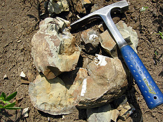
A broken concretion with fossils inside; Late Cretaceous Pierre shale, near Ekalaka, Montana.

Oxford Clay (Jurassic) exposed near Weymouth, England.


Ornithopod trackway at the Villar del Arzobispo Formation

Beach and cliffs, Egmont Bight The grey cliffs here are of Upper Kimmeridge Clay, and prone to erosion by storm waves coming in from the south-west. The small rocks in the foreground are the eroded remains of the foot of a mudslide from the Houns-tout cliff.


Horseshoe Canyon Formation exposed in Horseshoe Canyon near Drumheller, Alberta

Exposure of the Two Medicine Formation near "Egg Mountain" in northern Montana.

